What Is Considered a Direct Hit From a Hurricane? Lala Never Made Landfall — and Broke a 155-Year Record
At 5 p.m. Hawaii time on Saturday, Aug. 15, a forecaster at the Central Pacific Hurricane Center typed a sentence into an advisory that most people outside Hawaii never read: “Lala’s eyewall brushing the southern portion of the Big Island.” The storm’s center was 30 miles southwest of South Point, out over open water.
By the official record book, nothing happened that night. Hurricane Lala never made landfall in Hawaii. Not once.
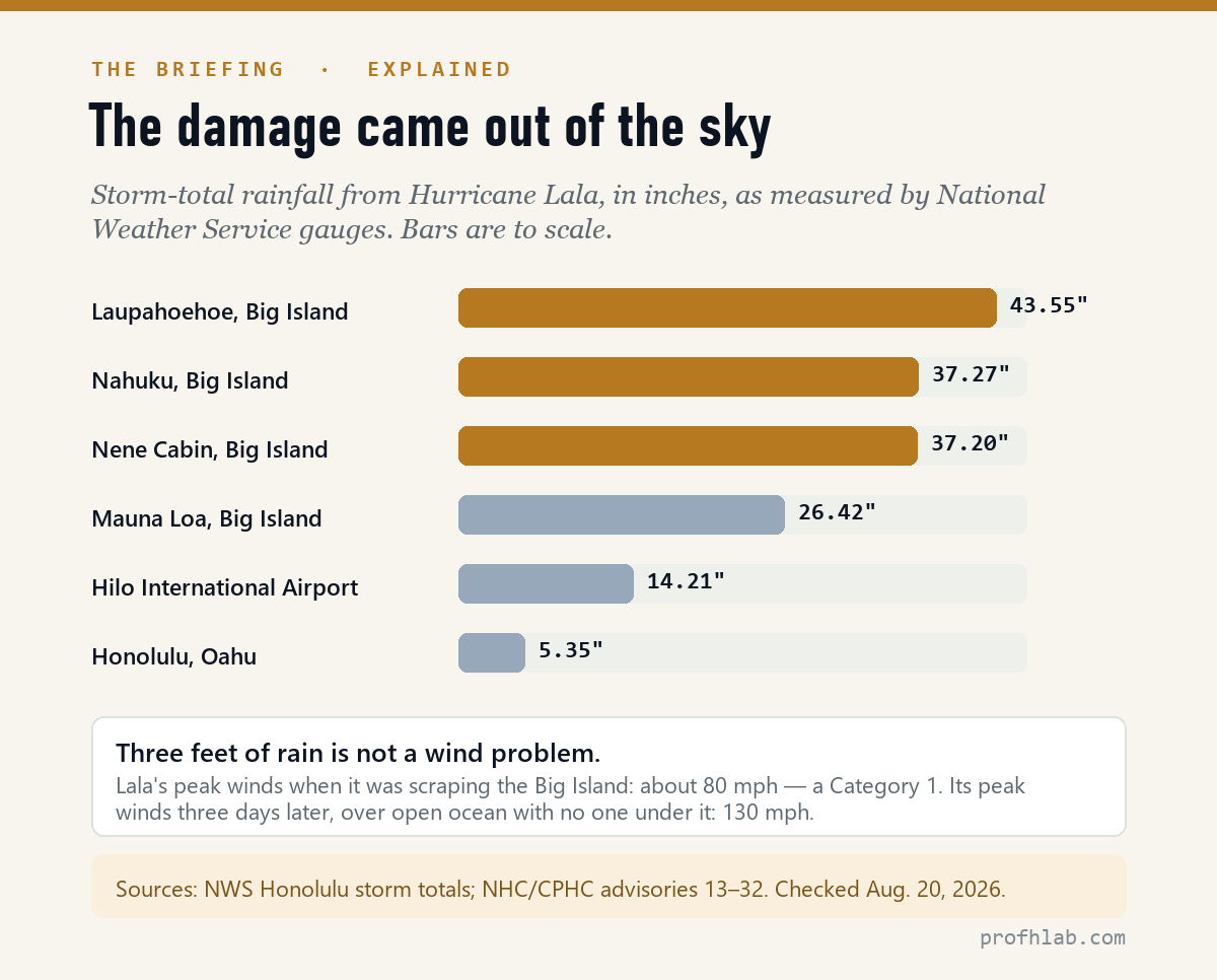
A rain gauge at Laupahoehoe, on the other side of the island, eventually measured 43.55 inches — more than three and a half feet of water. About 200,000 customers lost power. Landslides came down on communities near Naalehu. It was the first hurricane to directly hit the Big Island since 1871, a gap of 155 years.
That gap between “no landfall” and “worst storm in 155 years” is why searches for what is considered a direct hit from a hurricane spiked this week. It turns out the word people were waiting to hear was never going to come — and it wouldn’t have told them anything useful anyway.
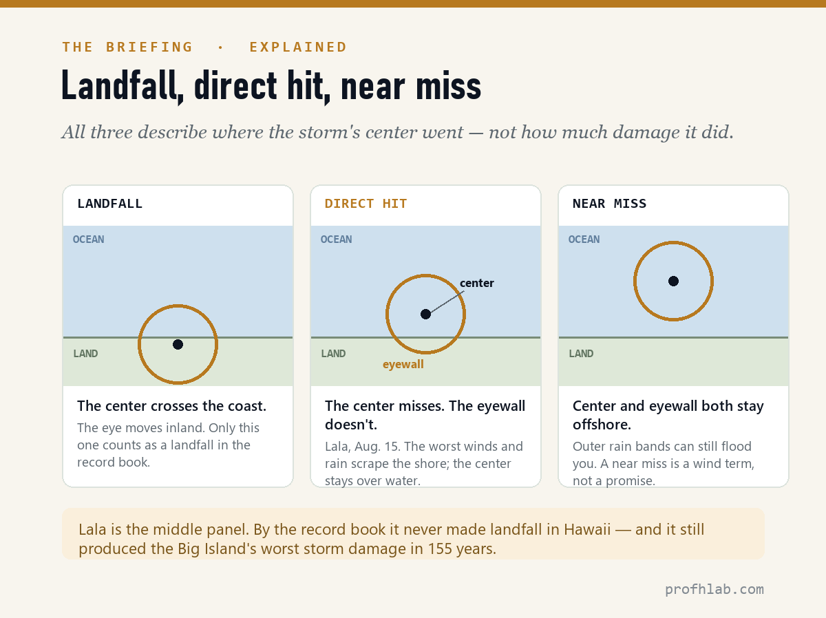
The short answer. A direct hit means the storm’s core — the eyewall, where the strongest winds are — reaches you, even if the center of the eye stays offshore. Landfall is narrower: it happens only when the storm’s surface center actually crosses the coastline. A storm can give you a direct hit without ever making landfall. That is exactly what Lala did to the Big Island.
Neither term measures rain, flooding, or landslides — the hazards that did nearly all of Lala’s damage.
What is considered a direct hit from a hurricane?
The National Hurricane Center keeps a public glossary, and its definition is more specific than most people expect:
“A close approach of a tropical cyclone to a particular location. For locations on the left-hand side of a tropical cyclone’s track (looking in the direction of motion), a direct hit occurs when the cyclone passes to within a distance equal to the cyclone’s radius of maximum wind.”
Unpack that. Every hurricane has a radius of maximum wind — the distance from the center out to the ring of strongest winds, the eyewall. If the storm passes closer to you than that distance, the worst of it has reached you. You got a direct hit. On the right-hand side of the track, where a hurricane’s forward motion adds to its rotational wind, the threshold is roughly doubled.
Notice what the definition does not require: it never asks whether the center touched land. A direct hit is about whether the dangerous part of the storm reached a place. Landfall is about where a single point — the center — happened to be.
The NHC also defines an indirect hit: a location that avoids the core but still gets hurricane-force winds or tides at least four feet above normal. And a strike, a wider bookkeeping circle 125 nautical miles across, offset to the right of the center.
What does landfall mean in a hurricane?
The NHC’s wording is one line: “The intersection of the surface center of a tropical cyclone with a coastline.”
That is the whole test. Not the eyewall. Not the rain shield, which can be hundreds of miles wide. The center — the single point forecasters track — has to cross the shore.
The term exists because climatologists need a consistent way to count storms across a century of records. It is a filing rule. It was never designed to tell a family whether to move the car uphill.
This also means a storm can make landfall more than once — crossing a peninsula, going back over water, and coming ashore again. And it means the outer rain bands, which usually arrive hours or even a day before the center, are not counted at all.
The thing to remember: “Landfall” answers a question about the storm. It does not answer a question about you. If a forecast says the center will stay offshore, the correct response is not relief — it is to go read the hazard section of the same advisory, which is where the rainfall and flooding language lives.
Lala never made landfall. Here is what it did instead.
The advisory record tells the story cleanly. On the morning of Aug. 15, Lala was a 65-mph tropical storm about 110 miles southeast of South Point, with outer rain bands already over the island. By 11 a.m. it was a hurricane at 75 mph, 65 miles out, and slowing down. By 5 p.m. it was 80 mph and 30 miles southwest of South Point, with the eyewall scraping the island’s southern end.
Then it stalled and wobbled. Forecasters had warned of “erratic motion” while the storm interacted with the Big Island — and a slow storm over mountains is the worst possible arrangement for rainfall.
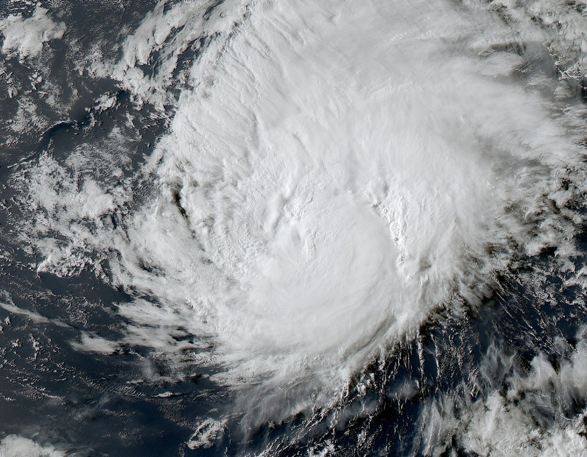
Hawaii’s mountains did the rest. When wet ocean air is forced up a volcanic slope it cools, and the water it was carrying has nowhere to go but down — a process called orographic lift. Park a tropical moisture conveyor against Mauna Loa for a day and the gauges fill up.
The consequences were not wind consequences. Flooding swept homes off their foundations near Naalehu. Saturated slopes gave way, and landslides cut off communities. About 200,000 customers across the state lost power, with 16 damaged transmission lines on the Big Island; officials warned that some rural restorations could take far longer than usual. More than 100 homes were damaged or destroyed statewide.
As of Aug. 19, news accounts reported three deaths connected to the storm, including a woman in her 90s in Naalehu. Official counts can change as searches conclude, and the Hawaii Emergency Management Agency is the authority on the final tally.
The strongest part of the storm hurt no one
Here is the detail that should change how you read a forecast. Lala’s winds when it was hurting the Big Island: about 80 mph, a Category 1. Three days later, on Aug. 19, out over empty ocean with nobody underneath it, Lala peaked at 130 mph — a Category 4.
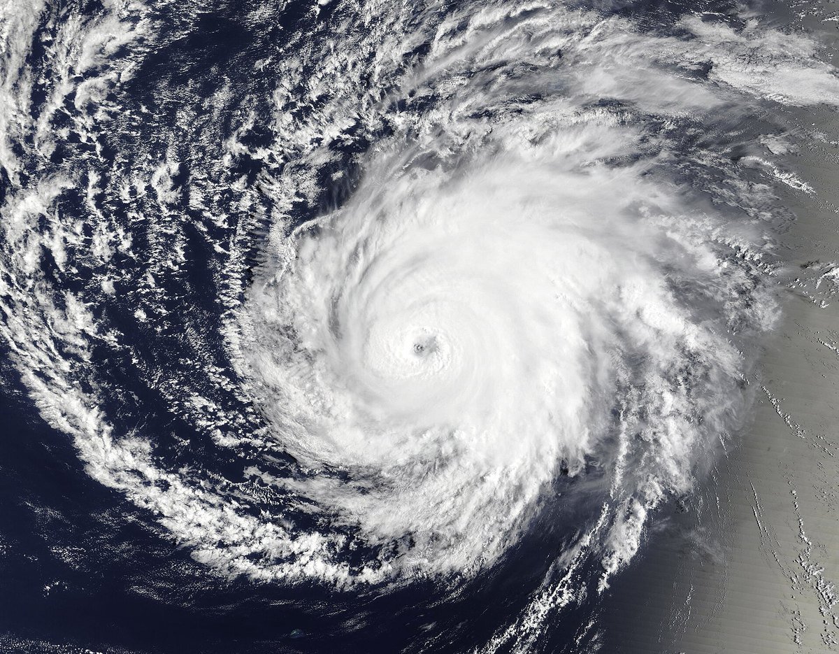
The prettier picture is the one that did no damage. That is not a coincidence or an irony; it is a direct consequence of what the Saffir-Simpson scale measures. The category number is a wind rating, taken at the storm’s strongest point. It says nothing about how much rain the storm holds, how fast it is moving, or what terrain it is about to meet.
A slow Category 1 over mountains can be far more destructive than a fast Category 4 over water. Lala was both storms, one week apart.
Why do hurricanes rarely hit Hawaii — and why didn’t that help?
Hawaii’s reputation for dodging hurricanes is earned. Four things protect the islands: a persistent subtropical high to the northeast that steers most storms west and away; relatively cool water north and east of the chain, below the roughly 80°F that hurricanes need; wind shear that tears storms apart as they approach; and pure geometry — the islands are a few thousand square miles of target in millions of square miles of ocean. Only two hurricanes in the modern record have made an official Hawaii landfall: Dot in 1959 and Iniki in 1992.
But look at what each of those defenses actually does. They weaken the wind and they nudge the track. None of them removes the water a tropical system is carrying.
That is the lesson of Lala. The shield worked exactly as advertised — the storm was sheared down to a Category 1, the center was steered just past the coast, and no landfall was recorded. And the island still took three and a half feet of rain, because a weakening storm is still an enormous, slow-moving bucket. (We wrote in why this hurricane season has been so quiet about how basin-wide conditions suppress storms; a quiet season and a safe island are not the same claim.)
Where Lala is now
As of the 11 p.m. HST advisory on Aug. 19, Lala was a 105-mph hurricane about 150 miles southwest of Maro Reef, moving north-northwest at 9 mph, and forecast to stay a hurricane through the weekend. A Hurricane Warning was in effect not for a city but for a stretch of the Papahanaumokuakea Marine National Monument, the chain of tiny atolls northwest of the main islands.
Nobody lives there in any ordinary sense. The advisory’s warning is about something else: large waves “will likely inundate some of the low-lying atolls.”

Those sand islands are the critical habitat for endangered Hawaiian monk seals and for millions of ground-nesting seabirds. A storm surge there does not knock down houses. It washes over the whole island.
Read the advisory’s hazards section, not the landfall headline
If a storm is ever pointed near you, these are the habits that survive the terminology:
- Skip the landfall headline; read the “Hazards Affecting Land” section of the actual NHC or CPHC advisory at nhc.noaa.gov. It is written in plain language and it lists rain, surge, wind, and surf separately.
- Treat a slow storm as a rain event. Forward speed matters more than category for flooding. A storm crawling at 8 mph will dump roughly twice what the same storm dumps at 16 mph.
- Know the two words. A Flash Flood Watch means conditions are favorable. A Flash Flood Warning means it is happening now — move to higher ground, and never drive through water of unknown depth.
- Landslide risk outlives the storm. Saturated slopes keep failing for days after the rain stops. If you are below a steep slope that has been soaked, stay alert after the sky clears.
- If you want to help, give to established organizations you sought out yourself. Disasters reliably bring a wave of fake charity calls and texts. Our guide to AI-era scams aimed at older Americans covers the tell-tale signs, including why you should never call back a number that arrived in a message.
Climate change and Lala: the physics is clear, the attribution isn’t
Will Lala reach the U.S. mainland? No. The forecast track takes it northwest, away from both Hawaii and North America, and Central Pacific storms that recurve at this latitude weaken over cold water.
Was this climate change? The honest answer is that no single storm can be assigned to it, and no responsible agency has issued an attribution study for Lala. What is well established is the physics: warmer air holds more moisture, which raises the ceiling on how much rain a given storm can produce. Rainfall is the part of the hurricane problem most clearly connected to warming — which makes Lala’s story, a wind-weak and water-heavy storm, a preview worth noticing.
And the volcano? The Big Island’s other running story is on the same clock. The U.S. Geological Survey said on Aug. 19 that Kilauea’s summit is re-inflating and that episode 54 of lava fountaining is likely between Aug. 21 and Aug. 27. We explained how those episodes work in why Kilauea keeps erupting in bursts.
Direct hit versus landfall, and why Hawaii is so rarely struck
What is considered a direct hit from a hurricane?
A direct hit occurs when a storm passes close enough that its core of strongest winds — the eyewall — reaches your location. The National Hurricane Center measures this using the radius of maximum wind: if the storm passes within that distance on the left side of its track (or roughly twice that distance on the right side), it counts as a direct hit. The center of the storm does not have to touch land.
What does landfall mean in a hurricane?
Landfall is defined by the National Hurricane Center as the intersection of the surface center of a tropical cyclone with a coastline. Only the center counts. Outer rain bands and even the eyewall can be over land without any landfall being recorded.
Did Hurricane Lala make landfall in Hawaii?
No. Lala’s center stayed offshore throughout, passing about 30 miles southwest of South Point on the evening of Aug. 15, 2026. Its eyewall did brush the southern Big Island, which makes it a direct hit — the first for the Big Island since an unnamed hurricane in 1871.
How much rain did Hurricane Lala drop on the Big Island?
National Weather Service gauges recorded a storm total of 43.55 inches at Laupahoehoe, with 37.27 inches at Nahuku and 37.20 inches at Nene Cabin. Hilo International Airport measured 14.21 inches and Honolulu, on Oahu, 5.35 inches.
Can a hurricane cause major damage without making landfall?
Yes, and it is common. Landfall describes the position of the storm’s center, not the reach of its hazards. Rainfall, flooding, landslides, storm surge, and hurricane-force gusts can all affect land while the center remains over water — which is precisely what happened in Hawaii in August 2026.
Why do hurricanes rarely hit Hawaii?
A subtropical high-pressure system northeast of the islands steers most storms westward and away, the surrounding water is often cooler than the roughly 80°F hurricanes need, wind shear frequently disrupts approaching systems, and the islands are a very small target in a very large ocean. Only two hurricanes in the modern record have made official landfall in Hawaii: Dot in 1959 and Iniki in 1992.
How many inches of rain is dangerous?
There is no single number, because it depends on how fast the rain falls and on the terrain. As a rule of thumb, rainfall rates above one to two inches per hour can produce flash flooding in almost any setting, and steep or already-saturated ground can fail with far less. The National Weather Service issues a Flash Flood Warning when flooding is imminent or occurring, and that warning matters more than any inch count.
Is Hurricane Lala still a threat?
As of the 11 p.m. HST advisory on Aug. 19, 2026, Lala remained a 105-mph hurricane moving away from the main Hawaiian Islands, with warnings in effect for portions of the Papahanaumokuakea Marine National Monument. The main islands were no longer under tropical storm or hurricane warnings, though flooding and landslide recovery continued. Always check the current advisory before making plans.
Sources
- NOAA Central Pacific Hurricane Center / National Hurricane Center, Hurricane Lala public advisories 13, 14, 15, 31 and 32 (Aug. 15–19, 2026).
- National Hurricane Center, Glossary of NHC Terms — definitions of landfall, direct hit, indirect hit, strike and center.
- National Weather Service Honolulu storm-total rainfall reports, as compiled Aug. 18, 2026.
- U.S. Geological Survey, Hawaiian Volcano Observatory Kilauea update, Aug. 19, 2026.
- NOAA Office of National Marine Sanctuaries, Papahanaumokuakea Marine National Monument.
- Damage, outage and casualty figures as reported by national news outlets, Aug. 15–19, 2026. All figures checked Aug. 20, 2026.
Keep reading
About the author. Prof. H teaches robotics and AI, and writes Prof H Lab — plain-English explanations built from primary sources. Every figure in this article comes from a government advisory, a gauge reading, or an official glossary, and each is dated. Corrections are published openly.
Prof.’s H Newsletter
One short email a month, with the numbers in it
What actually moved in AI hiring, AI prices, and the scams aimed at older Americans. Counted here, dated, and linked to the source. One email a month, and your address goes nowhere else.